
There are two upper sections of Johnnies Creek. The first part is a short III-IV gorge followed by a lake. The second is class II (III). When Johnnies is getting high, this is a fun alternate run if for some reason you don't want Bear or Wolf or the big bad Wolf (did someone mention Chinquapin?, I didn't think so)
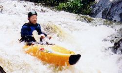
The top section quickly drops into a class III-IV gorge that is continuous and nicely technical. A little tougher than "Teddy" Bear Creek. There are a number of tight rapids, a few of which need scouting. One drop has a slot that feeds left to an undercut wall, another has a large slab rock in the middle of the river. This section is very nice at 4" on the new river right gage at the 'normal' run put-in. This run is tight and at a good level demands a quick move or two. One rapid towards the end of the steep section is called "In Memory Of #3". The rapid consists of a creek wide boulder pile/ledge drop of about 5 feet. 6 feet from the base of the drop is a semi-truck size slab wall of a boulder that is almost river wide - starting from river right. The right side of this boulder harbors a sieve, similar to Fist on the Russell Fork. The only way to run it at low water is hard left, with a strong boof then an immediate correction to the left, in order to avoid pitoning into the boulder. The boulder does not appear to be undercut, other than the sieve on the right. At higher water it opens up enough to hit a clean though tricky right to left line off the boof.
In the midst of the top section is 1.9 mile long Lake Lickskillet, which makes this section a bit less appealing than it otherwise might be. At the end is an earthen dam with a concrete slide. The slide is runnable. It's about 30 feet high and about 50 feet long. It is wide and the concrete is rough, so you don't go any faster then about 3 miles per hour between -2" and 4". We do have a landowner issue here. The landowner near or of the dam was pretty peeved when a group of 7 folks were scouting and running it recently. Since the creek can be legally accessed at Hwy 176 and multiple points downstream, it is legal to run. However, I'm not sure about the dam itself. In the future, the best course of action may be low key expeditious portage. After the dam is class I until the CR47 bridge.
The stretch of Johnnies from CR47 to CR275 is a pretty little gorge. Mostly flatwater, but the last mile has a few good class III drops. This would be a good, short, up and coming beginner run. You do have to walk around one tree as of late 2002. After a while you come to a 6 inch ledge, then a one foot tall ledge, and they keep on growing. Toward the end there are two or three Nantahala Falls type drops. Overall this section is mostly class II with one or two class III's. Most of the stuff below the dam is small wave train and rock avoidance. The few class III's are actually II+ or III- at low water, but are solid III at 4" or so. The creek is very narrow and will pick up the occasional strainer from time to time. Take-out at the usual run put-in just above or below the falls.
The gage for this run is on the CR275 bridge. On the river right bridge support, -2" is about minimum, while 4" is a good level.