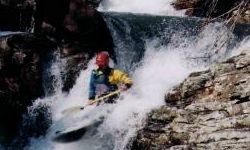
| Tight, fun, and short. You put in a farmers field, float/scrape
for 0.5 mile, then scout, walk, and/or run the big class V. You will, or at least better, not miss the big one.
As seen in Steep Creeekin and Tales of the Paddlesnake videos. The rest of the way is tight III and IV.
This is a very high quality run that is hard to catch. It has a checkered gage history. The old one at the put
in is now basically unreadable. The more recent one at CR47 was taken out with the old bridge. So late in 2008,
a new one was painted at CR47. 0' is good to juicy, so -6" or -0.5' may be roughly minimum. As with any small
watershed, the required LRC level depends a lot on how long ago the rain fell. Be courteous to landowners. |
|