
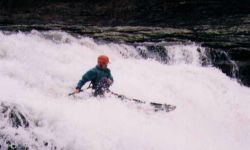
The first drop is the easiest on the river. The second rapid is called two out of three because if you go left, you may find a pin spot. In fact, this was the exact ratio when we ran left one time. So I like right, even though it is very tight and likes to collect trees. There is a short warmup section of III+/IV-, then things get pretty steep. Soon you will see the top of a shallow slide, which leads into a big slide best run center to slightly left of center. The first time you run it, as you crest the big slide, you will get a rush. Gorilla Constrictor follows the pool after the big slide. You don't want me of all people to tell you how to run GC - if you are worthy, you'll figure it out.
After GC, you used to able to put in above or below a drop with pin potential and a 4' drop. It now (9/04) is full of logs and the rocks may have moved to cause major pin issues. Just after that is a right to left curve leading into a sticky short slide run either left or right. Next may be Cliff Right, which features an eddy that will make your head spin followed by a drop with a rock right in the middle at lower levels. You then ride it out against or heading away from the river right wall. Pins and pain are possible in this rapid. The next drop used to smack you against the left wall, but was changed bigtime around the time of the 2003 earthquake. It now has a cleaner entrance but has a bad slot on the right and a pin rock in the center. Left of center is the way. A couple slightly longer and cool rapids follow. One is a follow the current down the left side, another ends up on river right with a neat boof very similar to seven foot falls. The last rapid is very unstable and now has a tree in it on the left. Finally you drop into LRC just above Canyon Mouth Park.
If anyone can help with more rapid names, please let us know via feedback to the left or the forum.
The cables in the last rapid were removed on 12/11/2000. These cables were evidently from a bridge built by the boy scouts many years ago that was probably washed out in the big flood that took place in the mid-80's (possibly when the Lake Lickskillet dam broke on the upper section).
You may be interested in running Upper Johnnies as a warm-up or easier alternative, depending on where you put-in.
Thanks to the folks at Streambeam, Johnnies now has an online gauge which is in the same location as the bridge gauge which has been in use for a long time. The correlation between the Streambeam and bridge gauges is not one-to-one, but is very linear and reliable. The online gauge and correlation information can be accessed via the link below.
Streambeam Johnnies Creek Gauge
The bridge gage is painted on the put-in river right bridge piling. I believe very (very) low is -6". 0" (top of the step) is sweet. Medium high is 2-4", and 4" is pretty padded out and getting high. It seems that 0" has more water that it used to as of late 2004. Over 4", I have no good insight for you, you are on your own. Johnnies essentially gets harder the higher it is, though a lot more rocks come into play. As a rule, you want around 12" on the LRC Rt 35 bridge, which is about 2100-2200 cfs.