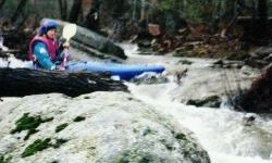
Tight but easy class II and III for high water days or recent
rain. Not much gradient but several fun rapids. A slide just after the confluence with Whipporwill at mile 2.4 and the take-out bridge rapid are the toughest of the run. Take the slide either
left or right, the hole at the bottom can be sticky. Take out at the normal Scarham put-in at Double Bridges or
continue down Scarham to Short and the lake. The Shoal
/ Scarham / Lower Short run is a full, fun day covering reasonable gradient varying from a mini-creek to a semi-big
creek on Short. One river wide log as of 1/23/2000.
As with many of the upper and skinnier Sand Mountain runs, it does not take more than an inch+ of rain or so in
mid-winter to be runnable. Town levels of 400+ or so are OK if you get there soon after the rains end when Town
is still rising. There may still be a gage at the put-in but I don't know what the good levels are. |