
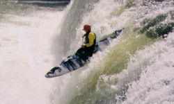
Short Creek has a squeaky-clean 18-foot waterfall, a thick stack of quality rapids and relatively straightforward (though strenuous) access logistics. Some people find fault with the water quality, a few manky sections, and the non-trivial lake paddle but despite this Short remains a favorite Alabama run and deserves strong consideration in any weekend of boating. In addition to the whitewater, the wildlife can also be interesting. A friendly goat, a pack of fluffy dogs, deer, coyotes, herons, and even eagles have been spotted at various points. Upper Short affords a nice 1 hour warm-up before the steep section and is a better parking option considering the rash of break-ins that have occurred on the other bridges. At the Martling Road bridge, the run begins with mellow class II warmup with a few III's at higher water. Downed trees are the main obstacle here; river wide log jams are common and some small slot rapids sometimes harbor wood. After two miles of easy water, another bridge comes into sight, signaling the approach of the main event: Short Creek Falls. Eddy out on the left downstream of the bridge, before the river left wall becomes a bluff blocking your exit.
The falls are very friendly and can be run just about anywhere that has water going over. Depending on where you go it's an 18 or 20 foot drop. The traditional line is about 10 feet off the left bank. Just don't go too far left, because if you land on the wrong side of the boil at the bottom, it will shove you into the mildly undercut shelf on the bottom left, where an amusing display of carping will likely ensue. Set safety from on top of this shelf. Eddy out behind it, hike back up and run it again. You can paddle behind the falls on the river right side, and watch your friends go over from behind the curtain. Pretty neat. After you get bored of the falls, a few class II-III boogie rapids follow. Keep an eye on the scenery ahead; when you see a sheer cliff face ahead on the right as the river bends left, Grotto Falls is coming up. Following a small slide and ledge combo, beach yourself on the large rock outcropping that divides the flow to scout Grotto. The main line is just a couple feet to the left of the rock you landed on, an easy 8- footer with big boof potential. At low water, keep your boat angled right to miss a piton rock on the left side of this drop. This can also be run further river left as a double drop, just stay away from the undercut bank.
Immediately following Grotto Falls is the infamous Tornado Sluice, which has caused many swims over the years. The line is down the turbulent left channel, entering from either side of a rock which divides the flow. You want to be on the right side of the chute as you finish off, angling downriver, to avoid the recirculating eddy and rock wall at the bottom left. If you get pushed into the wall, just ride it out and roll up before the creek gets too shallow.
After the triple stack of Grotto, Tornado Sluice, and Divided Highway, the action continues with Rock Cruncher, perhaps the biggest rapid after the falls. Catch an eddy on the left above the entrance to scout the full rapid. If it isn't an ELF day you can sneak down the left side, bouncing off a few rocks and into the pool below the rapid. The usual line is to work from center to right into an eddy on the right bank above the main drop; from here the line is down a chute headed back center to miss the big boulder on the right bank. No doubt you’ll spot a juicy mushroom of water at the bottom ripe for a boof – but watch out! A nasty flake rock is right in the center below the mushroom. Skim the left or right side to avoid getting crunched.
A few easy rapids follow Rock Cruncher. The next significant rapid starts after a long pool, where the river doglegs right and the left and center are obscured by large boulders. The creek widens significantly here and you'll bump and scrape through the top part of this rapid, which has a few possible routes; the most entertaining option is a tight 3' boof against the far left bank. When the creek begins to channelize again, be wary as the majority of the current barrels down into Little Woodall, a dangerously sticky hole which is known to recirculate boats and swimmers. The safe line is to power into the eddy to the left of the hole, beside an enormous rectangular rock, then wheelchair down the rocks which form the pool on the downstream side. The more adventurous may wish to run the hole off the left shoulder, but be prepared to set safety if anyone plans on doing so.
After Little Woodall, a congested boogie rapid leads to the confluence with Scarham Creek. Hike up and take a look at the last rapid on this tributary, known as Terminator (class IV or V), and run it if it looks good to go. Below here the creek widens significantly, and with the added flow from Scarham, presents some good play opportunities to celebrate finishing the hard stuff. Surf waves and fun boofs abound. In the old write-up Mark D. mentioned a good ender hole in the 2nd rapid past the confluence on river right, best at low water. On the last rapid before the lake, you can find a fun boof in a ditch on far river right if you look hard enough. The last eddy line on river left (or is it lake left?) is also good for stern squirts. Once you reach the flatwater, celebrate the fact that you made it down the notorious Short Crick, and prepare yourself for the 45-minute, 3-mile paddle out. Just follow the channel all the way to the boat ramp. When the lake doglegs to the left for the first time, don't get too close to the island or you'll run aground. On the right shore of the dogleg, Dry Creek comes in. It's easy to hike up and get a look at the last few rapids, if you're interested in running it.
Access Notes:
The listed address for the put in is approximate - look for a bridge over the creek with a
gravel pull off on
the river left, downstream side. It is tempting to park at the Hustleville Road bridge to
cut off the warmup
rapids, but there are no parking signs on both sides of the bridge. If the water is
high and you want a more interesting warmup, Drum Creek is a
tributary which enters just above the falls
and offers some nice class III water. See Alabama Whitewater for a description.
Gauge Notes:
The online gauge is operated by StreamBeam, a non-profit founded by a group of Alabama locals.
The Streambeam gauge has recently been replaced in a new location, after the first was washed
away in a flood. The new gauge has been installed at the Martling Rd. put-in, and features
a stick gauge as well to verify the level in-person. The new gauge appears to correlate almost exactly
with the AL 75 bridge gauge at low to medium flow ranges; look for at least 0.5' for a low run, 1' for good
water, and above 2' would be high. The correlation is still being solidified, so please submit any visuals to
Streambeam, and access the gauge below:
Short Creek Streambeam Gauge
The TVA Town Creek gauge can be a backup indicator of whether Short Creek is running.
If Town is over 400 CFS, there is a good chance Short will also
be running, as it's the next watershed over from Town.
The old painted gauge is on the river-right, downstream side of the upstream span (there are 2 spans) of the AL 75 bridge. It reads approximately the same of the StreamBeam gauge.
For what it's worth, we've run it at 4-5" on the AL 75 gauge and it was still doable and fun. A few rapids downstream of the falls required some creative maneuvering to run, but we didn't have to get out of our boats.
- write-up provided by Kellis Kincaid (with edits by Gaylon Partain, Mark D.)