Run: Swamp Creek      
Section: Upper      
         
Class: I-II (III)   Put-In: Hwy 231    
Gradient: 16.8'/mile, 1 mile@40'/mile   Take-Out: Hwy 22    
Length: 8 miles   Precip. Gages:      
Shuttle:     Delorme Gazeteer: P. 38 F3    
Water Q: Primary Gage: None    
Links: TOPO MAP Required Level: Visual     
  PICTURES Indicator Gage: Hatchet blw Rockford    
  TRIP REPORT Required Level: 700 cfs, 1000+ better    
  AERIAL PHOTO of Rapids          
Notes:            
In my quest to learn more about Socapatoy and Weogufka Creeks, Brad Thompson told me about Swamp Creek from Hwy 22 to CR 29 (Lower Swamp). I checked it out. As I was scanning around the topos for the area, I happened to see the word 'Rapids' and some relatively close elevation lines on the section above Hwy 22. Intrigued, I checked out the aerial photos on the terraservice site. Sure enough, little trails of white could be observed. Brad said "the term micro would be an overstatement (usually dry?)" for this stretch and he figured logjams could be a major problem. Never that easily deterred, I put it on my to-do list.

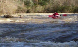
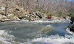
Swamp is indeed an enjoyable class I-II run with a relatively short section of fun II+ and III at about mile 2.5 or so. As of early 2005, logjams are not an issue at all. It would be a fun family paddle in the summer just after a good rain. The creek is at its narrowest at the put-in and take-out, but has a fairly wide streambed for most of the run. The first mile is quite flat and silted, but slowly the rocks begin to emerge until the fun mile begins. There are one or two 5-6' high straight-on drops that would really make a tandem flatwater canoe run entertaining. The steepest part of the rapids swings from bank to bank with eddies and even a wave or two if the water is high enough. After a calm stretch, a dam forces the flow into a culvert, but the dam is very easily portaged on the right on only wastes about 5' of gradient. A double drop just downstream is fun. The rest of the run has many stretches of flatwater and the odd shoal. No pool is outrageously long, and with copious water, the current will move throughout. Upper Swamp could easily be combined with Lower Swamp for a very full day of Central Alabama boating.

The shuttle is painless, just go through Rockford. There is plenty of parking at the take-out, but the put-in is tight right next to the bridge.


Run: Swamp Creek      
Section: Lower      
         
Class: I-II   Put-In: Hwy 22    
Gradient: 15'/mile, 1 mile@40'/mile   Take-Out: CR29    
Length: 3.5 miles   Precip. Gages:      
Shuttle:     Delorme Gazeteer: P. 38 F2    
Water Q: Primary Gage: None    
Links: TOPO MAP Required Level: Visual     
  PICTURES Indicator Gage: Hatchet blw Rockford    
  TRIP REPORT Required Level: 700, 1000+ better    
             
Notes:            
From Brad Thompson:
Swamp creek, which flows into the terminal end of Hatchett is a fun whitewater run when flowing. You can put in along HWY 22, just northeast of county road 29. The take out is county road 29 steel bridge, the same as lower Hatchett. A rock garden when dry but lots of rapids in this short run when it's up.

by Tommy Steele from a trip in late February 2006:

Lower Swamp Creek @ 1800 falling on the Hatchet gauge:

This is a gem of a creek. There are small shoals around most bends in the creek, a lot like the Hatchet for the first couple of miles. The first rapids require maneuvering around a large tree trunk. 10-15 minutes in, the second set of rapids may be a fun and fast II. Many easily avoided strainers lay partially across the creek throughout the run. At the third series of shoals the creek comes very close to a bridge over Hwy 22. A small stream feeds into the Swamp here, and there are some nice rocks to stop on. Further down, the banks vary from steep and rocky to sloping. An island splits the creek after a few minutes; the left is scrapy, but the right has a neat series of waves. In the last mile or so the gradient seems to pick up. There are a couple of fun, continuous II/II+ sets of rapids with lots of rocks barely submerged and plenty of eddys. Lots of rocks to avoid but great at this level. After the second of these rapids the gradient disappears and the creek joins the Hatchet at the steel bridge on CR 29.