
II (IV) high water
Socapatoy is a brief chunk of high quality whitewater that is well worth checking out if you are in the Central Alabama area (Hatchet, Alexander City, Sylacauga). It may be one of the best whitewater runs in Central Alabama. It has a decent watershed, but you need to catch it when Hatchet is running fairly high. Like many other creeks in this area, it's gradient is concentrated in a relatively short section where it drops into another larger creek, in this case Hatchet. The short steep section is referred to as Devil's Canyon. The entire lower section is called the cave run. You could run above this, but it is long and may have relatively few rapids. The CR 111 put-in road is the last road over the creek before it joins Hatchet, and the take-out is on Hatchet at Highway 231. The put-in is a 10 minute ride down a decent dirt road off Hwy 280 that would be real slick just after a rain. It meanders a lot, but is easy to follow since almost all the wrong turns are gated.
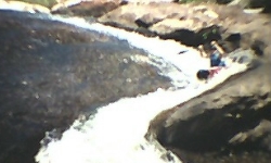
There is a rapid with a fair bit of drop just upstream of the put-in bridge that you might want to look at or carry up to run. It is then pretty flat for the first few miles. The end of the flat is abrupt. The meat of the run is really one big rapid with an impressive view from above. You start out with a class II rapid called Blindside. It shoots you down the creek into a double drop, 3' followed by a 4' waterfall. Then it sends you to the mouth of the biggest rapid on the run. There are two lines you could take. First, you could go down the left of the big boulder onto chicken falls (an 8' waterfall) which leads you to the slide rapid (pictured above), or you could take the line that leads to the frozen rope (on photo page). I think the option we chose was to run far right to left from the eddy just below the big boulder. This was a fast and very fun line (see video). There is a good pool at the bottom. The next hundred yards is a boulder garden with a few 3' drops in it. Finally there is attitude. It is a slushy rapid that will toss you around a little. At runnable water levels, this is a classic whitewater run. The whole Devil's Canyon stretch will be one big class IV with big hole potential at high water.
As of early 2005, what little deadfall there is can be avoided. The required level on Hatchet is somewhat of a guess. Also keep in mind that Hatchet has a long watershed, so it is best to look at recent rainfall in the Socapatoy area. Finally, check out the trip report linked above. It is pretty funny. They put-in farther upstream and at really low water, but the best tales are always born when things go awry. The easiest shuttle is to go north from the take-out on 231, turn right on CR 49 in Hanover, then go south on Hwy 280 to CR 111.