
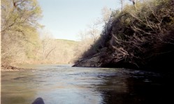
The Weogufka is a beautiful run. The put-in is just below the Management Area check in station in Mt. Moriah and I usually take out at the "Underwater Bridge" as it is known located in the Management Area.
Not sure about the road numbers, but the management area map would have them and you can get the map from the Game and Fish Division of Alabama. Not much for big white water, but it has a lot of Class I and II rapids which are fairly close together. Some of the highlights are large bluffs and rock cliffs and a place called Shoe Shop Cave about half way down on the left hand side of the river and Horse Stump Campground.
This is a great run for somebody looking for scenery and/or an introduction to white water. If the Hatchet is running, then it is running.
- Keith Fulbright
From Murray Carroll's archival notes:
1. On 2-11-96, Hatchet Creek was approximately 700 cfs; plenty of water on Weogufka at that level.
2. The put-in bridge for Section 2 of the creek has been replaced since Foshee's book was written and there was no painted gage as of 2-11-96.