
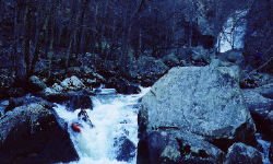
Yellow is not long. The whole run is drop/pool in nature - two of the drops really drop. Just downstream of the put in bridge, you can run a partially broken down 10' falls on the far right, or perhaps left at high water. This rapid is easily accessed on foot from the bridge down an old road on river left. This is where we judged water level. At a nice medium low level, this rapid had water going over the flat rock at the bottom and the undercut slab had a pillow (see pictures). The rest of the run can be broken down into three parts: Above the falls, the falls, and below the falls.
All of the rapids above the falls are at most class III+, with two exceptions. The first exception is a narrow undercut slot that simply did not go at our water level. It may fill in at higher water. The very next rapid is a class V, ~25' waterfall that none of us had the soft goods to run. Let us call it 'Vee Falls'. It is a big upstream facing vee slot that would perhaps be best boofed right. The left side is a cave at the bottom and the right side is undercut too. We found a difficult but reasonable portage route on river left. After this rapid, several more III's follow. When you pass a tributary on the left, heighten your search for the ultimate Alabama horizon line.
Missing the last eddy above the falls would entail at least paralysis and very well would involve passing from this life to another. Assuming you stopped above the falls, you will want to check the opening slide and sheer drop from river left. Once you've had enough, you can walk on the smooth uphill rock and meadow on river left until you get to where the cliff ends. You will be descending through not too steep woods down to the lake, or you can turn right and run the rapids below the falls. In all, the portage only took about 15 minutes once we figured out where to go.
There are about 4 rapids below the falls. We only saw the first two from above, and they looked like sieves at our level. At higher water they may open up. The last two rapids are class IV. The first had a lot of rocks to be dodged and a slot at the bottom. The last is an 8' falls which must be boofed hard right to avoid a rock at the bottom. The paddle across the lake is quite short.
Yellow does not take much water for a creek, and lasts longer than you would expect due to an upstream swamp. We ran it in late winter two days after a rain with the canyon at about 1200 cfs. In the summer, 1500 may be pretty low. Unlike most of the rest of the state, the USGS topographic map that covers Yellow is in 10', not 20' increments.
One final word about the two big portages. Planning is key. Scout out your route without your boat first, then go get the boat. This will save you a lot of time and energy. The walk at Vee Falls is just above brink level on river left, around a rock outcrop, then straight down to the river. It is not long but it is not easy. The big walk is best observed in person. This run is best made in the winter or early spring when underbrush is minimal for obvious reasons.
There is supposedly good climbing in this area...
