
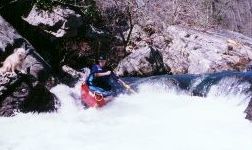
Most folks put-in at Lake Howard, but you can add three more miles by putting in near Cloudmont. I've never run this upper part and there appears to be minimal gradient. The optional rapid at the Lake Howard Dam is a multi-drop IV that is easily scouted or walked on river right. Just after that, two tight and fun rapids will make sure you are fully awake. Good class III stuff continues on and off until you get to Broken Nose. It will be semi-obvious, stay right to scout or run - the left drop will take you into the undercut (see pictures). Overall, comparable to the middle Tellico or a bit easier. As of 2/04, there are very few logs, and the few there are can be easily avoided at 250 cfs. At 250 cfs, it took us 15 minutes to paddle the flatwater at the bottom of the west fork, 20 minutes to get to Road 03, and an hour more to get to the 35 bridge. There are some sweet waves in the last two miles above the 35 bridge.
Multiple put-in and take outs are available. It is 3 miles from Cloudmont to Lake Howard, 4 miles from there to the confluence with the East Fork, then three miles to a river left forest road take-out (road 04). Road 05 would be the best take-out on river right, while Road 03 would be the best takeout on river left. Road 03 is rutted, but not too bad in a pick-up, or anything with ground clearance (I've heard 05 can be a quagmire at times, but check it out and let me know). 4WD may be needed on some of the hills if it has rained recently. See the above access map. Three or four more miles bring you to route 35 upstream of the falls. The river below the confluence is largely flat. The alternate take-out about 3 miles below the confluence avoids some flatwater, but delivers a long shuttle. To get to the alternate take-out in 1997, you took Crest Rd. north off Rt. 35 (east of Little River), drove about 3.4 miles and then turned left on forest road 02. After following 02 for 1.4 miles, turn right on road 04 and you'll be at the river.