
5'/mi. confluence to Rt. 35
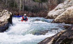
The put-in is below scenic Lake Lahusage dam. A low head dam is located one-half mile downstream and can be portaged on the right or run anywhere. All of the rapids occur before the confluence with the West Fork of the Little River at mile 8. At 1700 cfs, the river is pleasing Class II with two light Class III rapids and some big pools. Eddy turns are not an essential requirement. The last couple miles above the confluence are pretty flat.
The remaining 6 miles of river down to the Hwy. 35 take-out are Class I with some decent waves at good water. The first half of the combined section is almost completely flat but the 2nd half moves along and has a couple waves. 900 cfs is the extreme minimum while 1500 cfs is the start of the nice range. This run could be made with a good bit of water (2500 cfs? or more?) and things would really move coupled with good play spots. The class III's would rock at higher water. There are no logs to deal with as of 1/2002. (assistance from Murray Carroll)
Notes on the section below the confluence from Jason Smith:
Access along FS road 5 and FS road 3 is fine in 2wd if you have good clearance. Numerous hard bottom stream crossings, but gravel improvements have made the roads much better. 500 cfs is the minimum for this section, and 750 or above is a much cleaner run. Can be run at lower level than the East Fork, which needs at least 1000 cfs... This is a nice lower water alternative for the intermediate boater. Starts as easy Class I-II, then rapids are solid class II from Hartline Ford to HW 35, with one class II-III drop. Total run is 6.0 miles. Alternative run, putting in at Hartline Ford has more action and is a shorter - about 4 miles. This great short run that can be done in 2-3 hours.
Road 05 would be the best take-out on river right, while Road 03 is OK on river left. Road 03 is rutted, but not too bad in a pick-up, or anything with ground clearance. 4WD may be needed on some of the hills if it has rained recently. See the above access map. Three or four more miles bring you to route 35 upstream of the falls. The river below the confluence is largely flat. The alternate take-out about 3 miles below the confluence avoids some flatwater, but delivers a long shuttle. To get to the alternate take-out in 1997, you took Crest Rd. north off Rt. 35 (east of Little River), drove about 3.4 miles and then turned left on forest road 02. After following 02 for 1.4 miles, turn right on road 04 and you'll be at the river.
2013 update on takeouts: The Backcountry road number 5 would be impassable to anything short a 4 wheel vehicle with off road tires. The best take out now is river left off Back Country road 2 and then turn onto Back Country 04 to Billys Fork, these 2 roads passable by most cars.
The shuttle is long but simple. From the take-out, go east on 35, then left on CR15. In Menlo, GA, turn left on Hwy 48 and go up the hill to Riverhaven Rd, the last road before the East Fork bridge. The best put in now is river right parking on the road where you can see the dam river right near the entrance to Lookout Mtn Camp. Short scramble down to a put in below the dam. Watch for rebar in the dam debris right below the dam.