
A Jeep trail exists from the end of Keith Springs Mountain Road in TN at the Little Mountain Cemetery. A 1.5 to 2 mile drag will deposit you on Turkey Creek. Directions can be tricky. Start out past the cemetery, then go right following the sign to Turkey creek. Don't make any left turns. After the sign, there will be a 4 wheeler path off to the right. Follow this across the ridgetop. You'll drop down close to the water eventually, and we cut right down a creek just as we were about to go up a steep knob. If you follow the trail all the way, you'll end up at Poplar Creek. You could also bushwhack right at almost any time, but the run high up Turkey may be very narrow and bony, and possibly harbor many trees. Put your take-out vehicles on CR9 upstream of Estill Fork. We parked where the pavement ends but you may be able to go somewhat further up the gravel road. The shuttle may be the longest in the state, do yourself a favor and go to the take-out first. It needs to be flooding there to make the run, and you still really can't tell the level on Turkey.
When you finally put on, the action builds slowly, and you may scrape quite a bit. Fear not, about 0.5 miles above the amphitheater, you will encounter a great series of channelized slides and drops. These are all class IV, and are clean as of 9/17/04. They are all pretty simple, one even goes right under a cliff on the first part of a triple drop. It is time to really pay attention when you get past a pool with trees growing out of it followed by an undercut cliff on river right. A few drops later you must portage on river right to get around the waterfall that normally goes into a cave. Blundering into this would cause severe trauma. Ropes are required for boats and possibly boaters. It is not a bad free climb down.
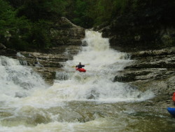
When Turkey is on, the normally dry amphitheater drops form an awesome series of class V drops. The problem is after the first smallish rapid with a sticky hole, the next drop is a 12' waterfall onto rocks into a moving pool feeding the main amphitheater slide. These two drops might be runnable by the psyched at higher water or at any level for those with a good feel for rock impact tolerance. Below the amphitheater are a series of fun slides and one or two 6' or so waterfalls. Then the rest is III+ boogie with more trees just above the confluence with Hurricane Creek. Hurricane is moving flatwater for about 4 miles.
Surprisingly, the water quality is pretty poor. Lots of suds. I don't give it a 3 chicken rating because it does not smell, but it probably deserves it.
The gradient is very hard to read, and I don't have the TN topos in the right format to get really good distances..