Shoal "in the Grove" starts off with a pretty easy and highly photogenic double waterfall (about 12'-14' per drop) at the former site of Neighbors Mill. If you ask nicely, you can park and put-in right next to the BP gas station on CR50 just off CR240. Then the run is class III/III+ for a while. Below a rapid where the current splits (the 3rd picture on the picture page), there is a severely undercut boulder. Undercut on the upstream side in the current. About the height that a body or kayak is wide. There is plenty of room for an upright boater to avoid it, but a swimmer or inverted boater would be swept right into it. Easy roping from the right.
Just after this the action begins to pick up with three distinct rapids in a row. They need names but the first is easy, while Percolator has a tricky eddy on the left with a boil that can mess you up and put you in the hole. The 3rd has a big and very fun slide followed by a narrow section. You'll probably be in a eddy on the right at the bottom of it when you will confront three drops in succession, the last of which is a 6' high 45 degree slide bounded by rocks at each end. The rock on the right is very big and the hole (I call it "Curt's hole") is nasty. Getting boats and boaters out of it can be a challenge. Hit the left edge of the current and you'll be fine.
After over a mile of fun stuff, fully 120' of the total drop is eaten up by Lion's Den, one monster multi-part rapid. This thing is perhaps the biggest in Alabama on a creek of reasonable size. Comprised of several 10'-20' drops one after another, some individual components can be run by the highly skilled and psyched. It terminates with a drop and hole under an enormous balanced rock. Logs can block the entrance, so you don't to want to go there. We portage river left, which looks easier than river right.
After the big one, there are a few more IVs. The first IV is the hardest, a move to the left over a boof, then a narrow passage to the bottom. A very dangerous sieve has been seen here at super low summer water levels. The next has another eddy hard to the left followed by a cool diagonal wave filled slide. The last is a narrow passage towards river left with holes which is best boofed at the end. Finally, there are some concluding III+'s that can be really bony at low water. Then you paddle the lake backwater for about 3/4 of a mile. The take-out is mighty convenient at the end of Buttery Road. It is the first paved road off CR50 on the left after CR50 starts to drop down towards the Tennessee River about 2 miles north of CR 240.
**There is a gage on the river left downstream support of the CR240 bridge upstream of the falls. 0' or very slightly less is minimum. The creek is wide here so a few inches can make a big difference. 2" is nice, 4" starts to get spicy, and 6" may be pretty high. We first ran it when the semi-flat rock between the first and second drops of the put-in waterfall had a thin but healthy film of water pouring over it. See the picture page, this was about perfect. We have run it a bit lower, but rocks were too plentiful. Too much higher and some holes will get sticky while others will be even more scary than normal, and you might wash into something you'd hoped to scout.
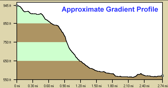
Below is a profile of the creek gradient. These data are not as accurate as the gradient field above but do give a graphical feel for how the gradient is distributed.