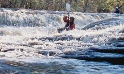
A nice class II-III run for decent/high water days. The run is
fairly tight and perhaps a slight step up from the Locust. Right at the put-in, there are fun, well spaced II+'s
with perhaps an easy III thrown in. If the whole run was like the first 1.5 miles, and it was 5 miles total, it
would be a great easy creek. As it is, the run is fun for a change of pace, a Scarham day extender, or an excellent
introduction to creek paddling. A slanted slide towards the end is the biggest rapid. Take out above the old mill
site or check you boat and spine for tolerance to rock landings. See Trip Report.
As of late 2004, there is a river wide log in a rapid just downstream of Hwy 75. See pictures and be careful.
** The new USGS gage one bridge upstream of Hwy 75 really takes the guess work out of whether this creek is up.
Since it is new, the minimum level is an educated guess, but is probably close. |
|