
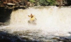
The first two miles down to Guest creek are a bunch of fun with many rapids, the odd pin spot, and maybe a few trees. Sticky holes can occur at high water. A fun double drop is near the top, and another 14' waterfall is easily run on the right. The falls drops on a shelf except for the right 1/4 or so. Not too far downstream, there are a few IV+'s. Always have a fail-safe eddy, because when the earth drops away you have reached the enormotron rapid. It drops a total of 50+' or so and sieves out about halfway through. The sieve is a non-starter at any level. The portage is somewhat long (maybe 10 minutes) but not that bad on river left once you get up the bank a ways. Ask Shane for a story on what not to do right above the sieve...
The Guest Creek confluence is at mile 2.0. Here, we got the extra 200 cfs boost and my fun meter quickly started hitting the peg on the right side of the dial during the high water run. At 6", this is where you finally have enough water to minimize boat abuse. The individual drops and are not too big, few are over 8' high, and eddies can be found. Care must be taken in several spots to avoid pinning one's craft. Many rapids are encountered. It is a joyous thing but at high water I was stressed. A walk or three may be required for various reasons at almost any level. Many more medium to big rapids dot the landscape until you hit the flatter section, where the transformation is abrupt.
*The part below the steep section is a washout through the trees, where high water really helps things along. Miller/Long Island Creek adds its flow at mile 4.8 (it smells). Taking out takes a tiny bit of imagination, we took out up a parallel creek near the gate at the end of CR 676, but we had a Brian's GPS. It can be found without a GPS, just paddle up the first side creek on the flats with any flow to it (and colder water). Take the right fork in the side creek. You could also take out along CR 676 on the flats, but you will have to paddle more flatwater. The slough is narrow, so wind may not be that bad a thing.
** A gage has been painted. It can be viewed on the downstream side of the put-in bridge concrete pillars from the river left side. I have verified that -4 to -6" is WAY too low. Repeat not our mistake. 0' is still too low. 6" is borderline boat abuse until you get about 2/3 of the way in. 9"-12" would probably be much fun. 1.5' is already getting high. Water level can also be judged by an angular, somewhat square rock about 100' downstream of the put in bridge on river left. High water will leave about 6-8" of air gap below the center stream side of the rock.