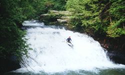
You can put-in below Kinlock Falls, or above it if you want the
thrill. It is a straightforward III+ 24' high two part slide into a deep pool. If you like what you see,
by all means have fun**. Use extreme caution while walking along the path around the falls, the bluff walls
are sheer and the footing can be treacherous during icy winter weather. Fatalities have occurred in this
area due to slips and falls. The first mile below the falls is probably the most unique and beautiful in
the state. The stream is tiny, "micro" would best describe it. The canyon walls plunge nearly
directly into this water wonderland. During winter, the canyon walls are coated with sheets of ice and long,
sparkling icicles. The stream is so small that at one drop, a wide beamed tandem canoe would probably not
pass through. After the first mile more feeder creeks join the flow and the bluff line backs slightly away
from the waters edge. Thompson Creek joins the flow to form the Sipsey River after 2.75 miles. The
trip description from this point on is the same as the Thompson Creek trip and includes
one Class II/III rapid. (Murray Carroll)
This is indeed a very beautiful run, especially so with leaves on the trees. As of June 2001, there were several
logjams that had to be dealt with. Two of these were big and no fun. Still a great trip. These may be gone as of
mid 2002. (**Mark D')
| Sipsey Gage Correlation |
| USGS |
CR60 wood gage |
| cfs |
feet |
| 744 |
4'+ |
| 600 |
3'+ |
| 380 |
2.4' |
| 355 |
2.0' |
| 220 |
1.5' |
| 15 |
0.5' |
|
|