
As of 2/3/02, there are two log jam portages on Thompson and five log jam portages on the upper Sipsey portion of the run.
(Murray Carroll)
| Sipsey Gage Correlation | |
| USGS | CR60 wood gage |
| cfs | feet |
| 744 | 4'+ |
| 600 | 3'+ |
| 380 | 2.4' |
| 355 | 2.0' |
| 220 | 1.5' |
| 15 | 0.5' |
|
|
|||||||||||||||||||||
| Run: | Thompson Creek | |||||||||||||||||||||
| Section: | ||||||||||||||||||||||
| Class: | I (III) | Put-In: | Northwest Rd (F.S. 208) | |||||||||||||||||||
| Gradient: | Take-Out: | Cranal Rd/County Road 60 | ||||||||||||||||||||
| Length: | 8.5 | Water Q: | ||||||||||||||||||||
| Shuttle: | Delorme Gazeteer: | P. 23 B9 | ||||||||||||||||||||
| Links: | TOPO MAP | Primary Gage: | Takeout bridge (CR 60) | |||||||||||||||||||
| MAP | Required Level: | 1.5', 220 cfs | ||||||||||||||||||||
| PICTURES | Indicator Gage: | |||||||||||||||||||||
| TRIP REPORT | Required Level: | |||||||||||||||||||||
| Notes: | ||||||||||||||||||||||
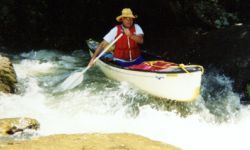
| Optimum flow 4.0'. Thompson Creek is a narrow creek which flows
south about 2.25 miles until it meets Hubbard Creek. The combined flow of the two creeks forms the Sipsey
River. Below the confluence of the creeks, a long pool is encountered; this pool signals the approach of
the only rapid on the Sipsey head waters. The pool is dammed at the end with all the water funnelling into
a chute on the left side of the river. The chute breaks back slightly to the right at the base of the drop
with the rocks obstructing a straight through run. The total drop across the rapid is four or five feet.
The rapid is Class II at 2.0' and becomes a Class III at 3.6' (the highest level that I have observed). Below
the rapid, large boulders sporadically rest in the river and on the banks. Bluffs line the river down the
entire length. A trip up the first large feeder branch south of the rapid will reward the hiker with a spectacular
waterfall. The waterfall is about 1/8 mile up the branch and out of sight of the river. Just above
the Borden Creek confluence is a small feeder creek on river left; just paddle up the creek and you will be at
the base of Fall Creek waterfall. After passing the Borden Creek confluence on river left, it's just a short
paddle to the takeout. As of 2/3/02, there are two log jam portages on Thompson and five log jam portages on the upper Sipsey portion of the run. (Murray Carroll)
|
||||||||||||||||||||||