
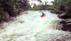
Milt and the boys ran Hicks in 2003 when the water was plentiful and the living was easy. They may have had a first descent. If Milt would send in some pictures and a description as he promised over a year ago, we'd have a nice page for you here. But alas, it is not so. Though he said he would, the check remains in the mail. And to think of all the carnage we've provided for Milt over the years. Rob Maxwell was on that trip and he has now posted a description and pictures on the AW site.
Anyway, Hicks Creek flows into Upper Bear. It won't run much, but heck, the Upper Bear doesn't run much, and Hicks is a tributary to it! There is one drop that will break a boat or a back that they carried. They carried another due to trees. But, they said it was pretty cool and they would do it again, so it is better than some of the runs in this guide. It is skinny and steep so trees will always be an issue. Keep your eyes open.
The put-in is on Rt 127. You have two take-out options. Since it is likely you'll be checking the Bear Creek gage on Rt 176, you may want to leave some vehicles there. Or, if you desire a shorter shuttle and less semi-flatwater at the end of Upper Bear, you can take out at the Rt 270 bridge on Bear.