Run: Blue Springs Creek      
Section:        
         
Class: II   Put-In: Chamblee Mill Rd. (see text)    
Gradient: 30, 60 (1.1)   Take-Out: CR 10 (on Mulberry)    
Length: 2.1, + 2.4 miles on Mulberry   Precip. Gage:      
Shuttle: Chamblee Mill / CR26 / CR10   Delorme Gazeteer: P. 25 E7    
Water Q: Primary Gage: Blue Springs Near Blountsville    
Links: TOPO MAP (lower frame) Required Level: 45    
  PICTURES Indicator Gage:      
  TRIP REPORT Required Level:      
Notes:            
This little stream drains the opposite side of the ridge from Graves Creek north of Blountsville. It actually has its own gage, probably to see how much sewer water Blountsville can pump into it. The creek starts out and ends up class II with nothing but class II in between. Some decent waves may open up at higher water. Above the bridge it goes over what must be the remains of Chamblees Mill. It has pretty decent gradient but does not do much with it. This would be a nice beginner or mellow water run given recent rains. There are 5-6 logs across the creek as of late 2/2001, but they are all easy walks or scrape-overs.

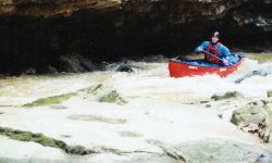
Blue Springs peaks and falls
incredibly fast. We ran it at 60, but 100 would be better. The gage is upstream of the whitewater section on the western edge of Blountsville, so the actual flow where you run it is higher than shown by the gage. It would be hard to have too much water on this. It is probably a good indicator gage for Graves creek, and may be useful for the Calvert Prong and Blackburn as well. The best place to put in is at the A-frame house where the road above the bridge over the stream curves away from the stream, just as the mini-gorge begins. This adds 0.8 miles to the run, otherwise it is 1.25 miles from the last bridge to the Mulberry. When you run this, the Mulberry will be high but mostly moving flatwater, so it goes by quickly. There are one or two pretty fast and smooth big waves between the creek confluence and the take-out.