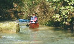
Beech Creek is a tiny tributary to Brushy Creek in Bankhead National
Forest. Beech Creek can be canoed from the bridge crossing on Forest Service Road 245 (Mount Olive Rd) to the confluence
with Brushy Creek. A trip down Beech will require an additional 6 mile trip down Brushy. The first mile below the
put-in bridge is rather flat and most of the adjacent shoreline is on private property. The last mile before the
junction with Brushy Creek is a narrow canyon with bluffs separated from the shoreline with hemlocks. A small waterfall
from a sidestream on the right will signal the approach to Brushy. See the Brushy Creek trip description for the remainder of this run.
Information for this trip description acquired from the "Bankhead Monitor", "Canoeing Brushy Creek"
(Murray Carroll)
The Shuttle is a semi-educated guess.
| Sipsey Gage Correlation |
| USGS |
CR60 wood gage |
| cfs |
feet |
| 744 |
4'+ |
| 600 |
3'+ |
| 380 |
2.4' |
| 355 |
2.0' |
| 220 |
1.5' |
| 15 |
0.5' |
|
|