
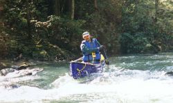
The put-in is at Brushy Lake; park at the picnic area (a fee is charged by the National Forest Service), canoe across the lake and take-out on the right side of the dam. The dam portage is fairly easy, but you have to lift your canoes over a fence and down a rocky hill. Generally, if the first shoal below the dam is runnable, there will be enough water to float the creek. Here's a rundown on major features:
Mile 1 - small feeder stream on west has a beautiful waterfall about 1/4 mile upstream.
Mile 2 - Beech Creek enters on river right.
Mile 2.8 - "The String of Beads"; a series of rocks strewn along the left shore constricting the flow of the creek. Coal Mine Branch enters on river left. The branch has a shallow, settler-dug coal mine in the bluff lines. There is beautiful waterfall at the head of the branch.
Mile 4.3 - Collier Creek enters on river right
Mile 6 - Sougahoagdee Creek enters on river right. Be sure to stop here and go up the creek to one of the most magnificent waterfalls in the forest. It isn't far and you won't want to miss this sight!
Mile 7 - Rush Creek enters on river left. I have heard that Rush is a great run in high water, but haven't tried it yet.
Mile 7.5 - A small waterfalls where a creek enters on river left.
Mile 8 - Take-out at Hickory Grove Road (FS Road 255).
Information for this trip taken from an article in the "Bankhead Monitor", "Canoeing Brushy Creek".
At 600 cfs on the Sipsey gauge, as of May 5, 2009 there were several strainers that required maneuvering and a couple that were real hazards with a fast flow.
At flows higer than 1100 cfs on the Sipsey gauge, the low bridge at the takeout could become a serious hazard . The fast moving water is right at the bridge level and the hydraullics are squirrelly around the bridge.
The shuttle for Brushy can be run to the east or west of the creek. The west route is Mt Olive Rd to CR 63 (by Grayson) to Hickory Grove Rd. The last turn is at a small church in a clearing. This route
is longer and slower, but the roads are much better after heavy rain (not as muddy). The faster route to the east is just Mt Olive Rd to Hickory Grove. Mt Olive Rd abruptly turns south at a triangular shaped
intersection just over a mile east of Brushy Lake. There is some parking on both sides at the takeout bridge. The south side (river right) has a little more room for turning around.