
There are stop signs at High Falls Park that the new sheriff demands you stop at. He also requested in a beligerant tone that all who enter should check in at the office. He made mention of the 15 mile an hour speed limit as well. - Ken Pevahouse
|
|
|||||
| Run: | Town Creek | |||||
| Section: | Lower | |||||
| Class: | III (V) | Put-In: | High Falls Park | |||
| Gradient: | 40,40,40,80,40,20 | Take-Out: | Rt. 227 up the hill | |||
| Length: | 5.8 + 1.4 mile lake paddle | Precip. Gages: | Henagar, Geraldine, Flat Rock, Grove Oak | |||
| Shuttle: | CR144 / CR356 / Hwy 227 | Delorme Gazeteer: | P. 26 A2/A3 | |||
| Water Q: | Primary Gage: | Town near Geraldine (TVA) | ||||
| Links: | TOPO MAP | Required Level: | 250 cfs | |||
| PICTURES | Indicator Gage: | |||||
| TRIP REPORT | Required Level: | |||||
| Notes: | High Falls & Blockage Pics! | GOOGLE MAP | ||||
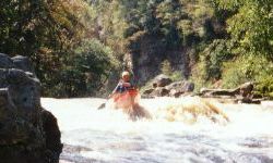
| This would be the most popular run in Alabama except for the
access. You have to get in High Falls Park, which is usually open after 10am on weekends, and then walk down
a hill. The vast majority will walk around the Blockage or Sleeping Giant Falls about 2/3 of the way down
the run, an easy V with a bad looking pin/undercut at the last drop. Except for the one V, the rest of the
run is consistently fun, open, creeky, class III. There are something like 18 class III rapids, for not one of
which do I know the name. Then you paddle the lake for 1.5 miles and grunt up a hill at the takeout. The
takeout trail starts next to an small, old fishing shack. The parking for it is possibly legal along Rt. 227 at
a wide gravel area just west of the barricaded eagle watching area. I may do a map someday... There are stop signs at High Falls Park that the new sheriff demands you stop at. He also requested in a beligerant tone that all who enter should check in at the office. He made mention of the 15 mile an hour speed limit as well. - Ken Pevahouse |
||||||