
There are 2 gauges painted on the bridge... I believe the one you go by is painted on the downstream side... there's another on the upstream side with the base of the piling at 0". If I'm correct, that reads around half a foot on the downstream gauge (i.e. low, but runnable). - JD (yet another example of the perils of multiple gages - ed.)
Early 2005 notes:
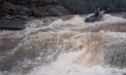
Things have changed hopefully for the better. The property at the put bridge is private with the landowner living near the RR crossing. His name is Trig and he charges $2.00/canoe to put in on his property just above the bridge. This is a much better put in than the old one. He will also let you park near the tracks. All this means a little more security for what was once a very risky place to leave your vehicle. The take-out has also changed. You can now park on the grassy area in between old and new 77. This avoids any problems with the restaurant at Waldo. The run was at 2ft. on the put in bridge. The gauge is barely visible. Maybe Trig will let you repaint it. This level presents a solid class III and IV run. Rob Roy is runnable, but there is only 20 yds. for recovery before the next big river wide wave/hole. We all made it through dry. The run is straight down the middle punching through the big wave at the bottom. Our only strainer was about a mile below Rob Roy. We encountered a tree across the creek on a right hand turn where a little island and rock makes a pour over in the middle of the creek. Most of the water goes right. A big tree is lodged on this rock/island blocking the whole creek. You could go left of this rock/island but be prepared to drop into a big hole. We took out on the right and carried around the tree. After this, it is just big waves and holes all the way to the takeout. This has to be one the premier whitewater runs in Alabama. Fletcher Scott, Joe Harrison and Raymond Butler ..
More from Tom Welander:
1) The owners of the land surrounding the put-in live in the house nearest the put-in. They are pursuing a back-to-the-land/sustainable/permaculture lifestyle. Along with teaching you which wild plants to eat, they offer a variety of services for boaters and hikers, including parking, launching, camping, etc. on their land. We happily paid $2/boat to launch and park in their yard after witnessing the swath of destruction attributed to the local hooligans who've been breaking into cars and dismantling the bridge railings with sledgehammers.
2) I'm supplying the MapQuest shuttle URL after mistakenly putting in farther upstream at the Clairmont Springs Rd bridge. Big mistake! Deadfalls galore. Lesley White, the farmer living there, cheerfully greeted us as we were hiking out past his farm and directed us to the correct put-in.
put-in
Trig & LaVerne (last name Gan____?), Red Wagon Retreat, 256-362-2592
600 Skyline Dr (aka Skyway Mtwy)
Talladega, AL 35160-5248
take-out
Old Mill Restaurant 256-761-0043
57900 Al Highway 77
Talladega, AL 35160-4034
mapquest shuttle URL
3) I'd consider it a full class below Town Ck.
4) Level was 1.2', old Waldo Bridge, downstream side. USGS Alpine peaked 2800cfs day before and was falling through 800s and 700s during our run. Ample.
*USGS put the Alpine gage online. Let us know if you can correlate it with levels at the bridge. It looks like there is so much flatwater between the Waldo Bridge and Alpine that it may be of somewhat limited use.
Finally, as of late 2010:
Maggie Johnston now owns the cabin on the hill across Talladega Creek from the Waldo Old Mill restaurant and rents it out as a guest house. This as an option for boaters who are interested in paddling Talladega Creek, Hatchet Creek or others in the area. See her VRBO site