
Sugar Creek is one of the many Locust tributaries falling in from the north. Like Graves, Big Scirum, and Austin, Sugar needs a good rain to get it going (John suggests a buttload to be exact). Sugar runs south out of Guinn Cove, which is just a couple miles east of Bangor. The put-in is a minor issue since no road crosses the creek as it flows through the flat cove area. This means you have to deal with at least 1.5 miles of flat water & a couple of log jams before the steep section. Aside from the logs, the water moves through this top section pretty well. Alternate put-ins may exist, but we discretely put in near a driveway.
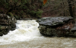
After many small, swampy tribs, the hills start tightening up, a few rocks and couple of shoals appear, then a decent rapid, and about 200' downstream from this, the first rapid of the steep section. It is the only rapid in the first mile of the steep section. It's also about a mile long. Cascading tribs are not in short supply and neither is the continuous III+/IV- action. After a chute/slot/undercut, you drop into a beautiful, bluff-lined gorge with water intermittently cascading in from both bluffs. The gorge runs approximately 1/2 mile and has more of a slot-chute rapid type feel. Maybe drop-poolish, but pretty short on the 'pools'. There are some slidish rapids, anf then a shoal-cliff like rapid that may remind you of the Icebox on Line Creek. The gorge concludes with a super cool, padded pillow-chute. The next ~3/4 miles keeps on truckin', similar to the first good mile, but maybe a little more fluffy & a little less technical. About ~1/3-1/4 mile before the 160 bridge things ease up. There are logs above and across at the bridge.
The wood wasn't bad, the tougher logs may have been in the top flatwater. There were 3-4 logs to deal with in the flat section, and maybe the same amount in the steep section. I'd probably class the last 2.5-2.75 miles continuous continuous 3+ micro... but there were 4-ish elements. That second 'continuous' is not an accident... it's frikkin' con-tin-you-us. Sometimes it reminded me of Line Creek, sometimes Graves Creek on steroids and in the gym every day. It is sort of similar to Big Scirum without the big drops. Super clean riverbank. The only trash I saw were the remains of 2 five gallon buckets. If anyone has run it, knows any land owners near the top, or any other info let us know, because this one warrants additional runs.