
Highway 33
The Sipsey River is Alabama's only "Wild and Scenic" designated river. This run is entirely within the Bankhead National Forest located in north Alabama. The river is generally runnable throughout the winter months and into the early spring. Runnable levels on the Sipsey occur only sporadically during the summer and fall months.
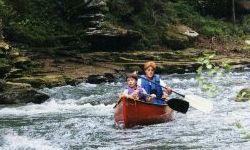
The put-in is at the Sipsey Recreation Area on County Road 60. The recreation area has a large paved parking lot, picnic tables, restrooms and a sloping ramp, making it one of the most convenient river launching sites in the state. The river downstream of the launch site is a combination of vertical canyon walls and steep hillsides. The flow of the steam is continuous and the water color ranges from clear to deep turquoise in the pools. Shoal areas appear frequently and add to the excitement for beginner canoeists. Only one actual rapid occurs at a spot where the river necks down to the right. There is actually very little drop across the rapid, but standing waves form at the bottom and give a bouncy ride. At high water levels the standing waves will increase in size. There is a boulder in the center of the rapid which has wrapped several canoes. [Some call this rapid 100 yard dash].
As of August 2009, there were no strainers that required maneuvering or that had to portaged when the flow was about 120cfs.
The river runs through continuously forested areas for 8.8 miles to the first possible takeout on the left side of the river. The takeout area can be recognized by the remains of a low water bridge structure. This takeout area can be accessed by taking F. S. Road 234 east off of State Highway 33. Another takeout area occurs about 3/4 of a mile downstream at the Highway 33 Bridge. The river below Highway 33 offers more outstanding scenery, but the flow of the stream is halted by the impounded waters of Smith Lake.
Canoe camping opportunities on the Sipsey are the best in Alabama. Most of the land along the river banks is a part of the national forest where there are no restrictions on camping (except during gun deer hunt dates on the Wildlife Management Area). A small portion of the land along the river is private. The only problem that you will have is making a decision on which picturesque camp site to choose. (Murray Carroll)
| Sipsey Gage Correlation | |
| If the USGS gage reads this, then the wood gage will be at the following level... | |
| USGS | CR60 wood gage |
| cfs | feet |
| 744 | 4'+ |
| 600 | 3'+ |
| 380 | 2.4' |
| 355 | 2.0' |
| 220 | 1.5' |
| 15 | 0.5' |