Schultz Creek is a beautiful spring-fed creek that drops into
the Cahaba right along the Fall Line. The Fall Line is a geologic feature in the Southeast that separates the Appalachian
Mountain region from the Coastal Plain, and most every stream that crosses it from Alabama to South Carolina will
have a series of shoals or drops there. Schultz is small, but is runnable (or at least scrapeable) most of the
year due to generous springs located upstream. The water is clear, cold, and clean. The drops are mostly class
II shoals separated by small pools, with the occasional easy III ['Bibb County class III', as opposed to 'DeKalb
County class III' if this makes no sense, keep paddling, it will someday] thrown in for good measure. Limestone
bluffs shroud the small creek most of the way, offering a great place to jump into the cold swimming holes found
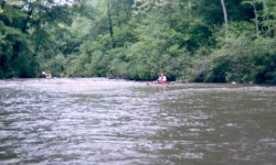
in the pools between drops. Once you reach the Cahaba River, There are a couple of drops in the 1-2 foot range
not far downstream. Take-out is on the river left at the Cahaba Historical Park 40 yards before you reach the bridge.
Take a fishing rod if you have the time; I have caught as many as 15 fish in a single morning here.
*From 219 bridge, if the first rapid has enough water, you can make it. Good levels might be reflected by a reading
of 1000cfs or more at Cahaba@Centreville gauge.
**Put in on Hwy 5 or Hwy 219. The Hwy 5 put-in gives more whitewater, but the access is steep. Hwy 219 has good
parking and easy access.
- Shane Hulsey |
|