
A fun, wide, play river, the Mulberry Fork of the Warrior is one of the most popular rivers in the state and my personal favorite freestyle run in the Southeast. Comparable to a mini version of the Dries of the New, it is challenging enough for the beginner / intermediate paddler but in chance leaves something great for advanced paddlers as well. The run is short but has some of the most pristine surfing waves in the Southeast United States and a few surfing holes that dot the run at different levels. I have put in parentheses what feet levels the features come in for the painted bridge gauge. Be careful at the first bridge. The most dangerous thing on the river are trees pinned on first bridge at high water. Just kick the field goal right down the middle.
The first rapid spot you really come to is Training Wheel (0.3-1.5 ft.), which is a great hole on the river right bank but can be shallow but great for paddlers to learn how to do 360 degree spins which is essential to learning how to surf any feature on any river and keeping you comfortable when the day comes that you get stuck in your first hole. The next rapid gets divided in the middle of the river by a rock. There will be a rock pourover on the river left bank or a large hole at high water that you need to dodge. If the water is high enough just ahead is one of the most holes around for just throwing big tricks. This hole is called Joe Momma's Hole (10-13 feet) which you will notice even at smaller levels due to the long flat rock on the left bank. Just take that hole and multiple it by 1000. After a short flat deep section of flatwater as you approach the cliffs on the right, the most symmetrical surfable wave called Lunch Stop (2.6-5.2 ft.) appears on the left. It simply gets bigger and more powerful as the water gets higher with a great wave just downstream at higher water called Dessert Wave (5.5-8.0 ft.) At higher levels there is a great wave at the bottom of the rapid that is great for surfing and doing downriver moves on. After Lunch Stop you have Mary's Hole (1- 8 ft.), which is a great little surf wave with a small wanna-be tube. This spot is great for trying downriver wavewheels and kickflips.
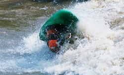
The last and most well known rapid, Hawaii 5-O Wave, is well known as a park and play spot at the Birmingham Canoe Club take-out. Watch out for neighbors and be discreet and courteous of all landowners. If at all possible please just park on the bluff side of the road making it easier on everyone. At the right level the best freestyle rapid in the world forms at 5-0. As much as I have traveled I have never witnessed one rapid with so many high class waves all in such a short ¼ mile distance. At the top of the rapid you have a great hole for the advanced playboater called Doo Doo Hole (4-6.5 ft.). Doo Doo Hole can be sticky and let you know who is in charge but to the advanced playboater offer up all the big moves. Do not exhaust yourself too quickly because you have a lot more waves to surf or survive. After Doo Doo Hole you will be followed by parallel waves on the left and right. The river left wave is called Mini Garb (6-8.5 ft.). At levels exceeding 11 feet the best wave in Alabama comes in on the right bank. This wave is called Corner Pocket Wave (11-15 ft.) that easily exceeds 15 feet in height. When you surf Corner Pocket Wave and you surf down the green face the sun behind you actually puts a shadow of you the green that dwarfs you when you turn around because you are not able to see the sun due to the top of the wave blocking it. If you surf hard left as you come off Corner Pocket Wave you will catch Party Surf Wave which is really fun to surf with 1.5 buddies. This most common wave is called Hawaii 5-0 (0.3-10.5 ft.), which is great at lower and higher levels and one of the most consistent features on the Mulberry Fork due to all levels of paddlers being able to surf it. At lower flows it can be shallow to tuck tight and at higher flows it can be one of the best surfs of your life. At higher flows the Alabama favorite comes in. This wave is named Joe Momma's Butt (5-12 ft.) due to fact that it is almost as good as your Mom's butt. This hole/wave is surfed by all at higher water and is truly just fun to surf. It only grows with water and gains power as 5-0 wave disappears. The last wave called Last but not Least (0.3- 10.5 ft.) is there at all levels but gets more fun as the water is at high levels. Make sure to eddy left or right at higher levels quickly and watch out for trees and other debris floating downstream which over the years have included: trees, chicken house, BFI garbage cans, unopened cans of Slim Jims, oil canisters, kegs, boats, broken canoes, basketballs and many others...
Thanks to Streambeam, the Mulberry sports an electronic gauge which correlates roughly with the historical gauge on the bridge piling. User reports have demonstrated roughly +/- 0.25' difference between the two in most flow conditions. This gauge can be accessed below:
Streambeam Mulberry Gauge
Note:
Occasionally, the Streambeam gauge may be down due to maintenance or hosting issues. In such cases, the level on the Mulberry can be estimated using the USGS gauge, which is far downstream of the usual whitewater stretch. To get the bridge painted level from the USGS reading: multiply the USGS reading by 0.75 then subtract 2.9 [Bridge = (0.75 * USGS) - 2.9 ].
To get the USGS level from the bridge painted level: add 2.9 to the bridge level then multiply by 1.333 [ USGS = (Bridge + 2.9) * 1.333 ].
The Mulberry can be a great learning river due to well positioned eddies and length of the river (If you get cold the takeout is nor far away). The Upper run can extend the fun at high water for 10 more miles if the level is over 1.5'-2' at the old 31 bridge. Put-in is the old Rt. 31 bridge in Garden City just upstream (East) of the bridge now in use. The BCC takeout is on a lot in Whitewater Bend. Once you find the put-in go South on Rt. 31. After a few miles, Philpot Rd. turns West off Rt. 31 just South of Bangor, then bear towards Whitewater Bend. The BCC access is at the end of the road.
To get to the river from the South, take Interstate 65 exit 287 onto Hwy 31. From the North, I-65 exit 292 on Rt 91 East/North, then bear right at what may be CR509 until you get to Garden City. CR26 cuts an almost direct line from Blountsville if you happen to be near the Locust.