After you put in, you run a big boney slide, then you portage that waterfall in the background of one of the pictures on the picture page. The waterfall is about 40' high and falls on flat rocks. It can be easily reached from Hwy 71 by taking the ATV 'road' just north of the put-in bridge. The steep stuff starts right after the falls.
Mark Cumnock:
Where do you start to describe a run that is like no other? First I have that heard described that Miller is a sieve run, and that it is Dirty Creeking. Like everyone in the world, everyone has his own opinion, so here is mine. I don't like to class runs, per say class III / class V. I believe in comparing runs of other creeks although no two runs are the same, and water levels are the biggest personality changer of a creek.
When it comes to Miller it compares to the Lower Cullasaja in North Carolina at high water which gives it's push (on the open rapids), and Morgan Creek in East Tennessee at Moderate levels (on the tight rapids) which gives it slots and dry boof lines, and Brush Creek (Roaring Creek, Tennessee side creek) for it's portage-scouting. If you like these kinds of runs and you think Bear Creek in Georgia as an opened up run, and Johnnies Creek is a fun run including Gorilla Constrictor, then Miller might be your cup of tea. If you like an easy shuttle, easy take-outs and put-ins, Miller may not be for you. For me and I hope others if you like an adventure of testing yourself, mentally and physically this is a true renaissance run. The rapids are set-up rapids, to where one minute you are making your hard move with your boat, mind and timing and then the next minute you are making decisions on where to scout, catch your breath, and choose your next line. Also the personality of Miller comes from the goal, of being with a tight team of paddlers that you are depending on more for more than your shuttle run, and portaging is an "ends to the means", and taking one eddy at a time is your mindset.
To me some of the rapids don't stand out, you have the feeling you are in a maze, that line you took, may have lead you to a dead-end and you look around and you see an opened spot, and it would have changed everything, you have this same experience on Morgan Creek (Tenn.). But there also rapids that really stand out such as Paraplegic Falls, Coo-Coo for Coccoa Puffs, When-in Doubt, The Slide, which is the first rapid and how do you name a rapid everyone can see from the road. So I believe instead of the dead-end scheme, come back another day and get the run wired. This is how the Green in North Carolina turned from a Hair Run, into a Tune-up run. (Lower water levels helped also) Yet I digress.
The run will be running when Jones is starting to get up and Town is starting to drop, or steadily hold its own. It is nice to wait after a rain to let things settle out so you won't be in a flash flood; you really want to dial in this run. Let it be known that Miller is challenging at all levels and that to me that is part of the beauty of this run. Brian Collins and I found this to be true at all levels. Also it was first run by Jim Little, Brian Collins, Mike Camp, Justin Howard and myself. I find that a group of more than six is too much, and a group of three is a must. Assume everything is undercut; we ran into a group of cavers leaving the gorge on our first run, and actually saw water going into caves. Do not put on if The Slide is real boney, you want water to slide with you at the falls, no push, and no scrape. If you scrape it's easy to get in you car on find another run such as Coon Creek. We would do this at the falls before setting up the shuttle. The reason for this is that at low levels, your paddle will turn into a hike when you hit the valley, for the water finally hits a pool and goes underwater, just as Brush Creek at Dunlap Tennessee does. It reappears once you hit the Tennessee River water table. At just a little bit of more water this problem will disappear, and not the water.
The takeout paddle can be tricky especially when the Tennessee River is down, Brian and I first took a first descent down Long Island creek, which forks into Miller. We found Long Creek to be a disappointment, no real rapids to mention, but it did help for a warm-up to paddle out for Miller. BUT an easier way we learned for Miller was to take a GPS. The paddle out is confusing due to a backwater problem created from flooding Miller from the Tennessee River. A GPS makes a major problem a minor problem and leaves out the confusion when being tired from making it to the valley.
I hope this brief description helps in making your mind up if Miller is for you. It's one of the best in Alabama.
Sloan Bryan:
Miller is a long, hard trip. The shuttle is long, the portages are tough/long, the lake paddle is long and confusing with a total amount of flat water paddling around six to seven miles. We did it when Jones was running about eight inches or so. If you do it though, you will have completed one of the toughest in the state. Enjoyable?
I can only say that I'm glad we did it, but it wasn't the most epic run I've done, nor do any particular rapids pop into mind that were just absolutely awesome, it is the ultimate example of what Mike Huff called "dirty creeking" (very constricted, rocky slots, shallow power moves, etc.). Post it if you do it, I'd like to hear another opinion.
The take-out can be found without a GPS if you trust your instincts. Park your vehicle at the gate which stops you from driving any further up the road on the south (river left) side of the lake section of the creek. Then, after you hit the confluence with Long Island, then Lively, you will hit the flats. After a while, you will see the first side creek with any (very slow) moving water. Paddle up that creek, take the right fork, and you'll be at the road in about 5 minutes.
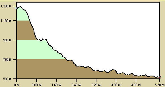
Below is a profile of the creek gradient. These data are not as accurate as the gradient field above but do give a graphical feel for how the gradient is distributed.