Brief but amusing if you happen to be at the Mulberry
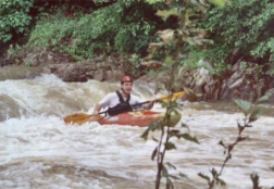
and there is many many water. Watch for logs, especially when you go under the road. The run is less than a mile long but has enough gradient to produce three fairly continuous
strong class III rapids along with a few II's at moderate/high water. It is quite tight and can be a real conveyor
belt on amphetamines. It needs lots of water to make it maximally speedy, though. Of particular interest is
a rapid just above the bridge under Rt. 5 which sports a slight horizon line Further on is a longer rapid. But
very soon the low water bridge takeout is upon you. Save yourself the trouble and go no further, there are a couple
small surfing waves beyond but after that all you'll find is pasture. Minimum is probably around 5'-6' on the Mulberry 31 bridge gage, but any time water is abundant and you are in the
area, check it out. Caution should be exercised before a run to ensure knowledge of any strainers in fast water
sections; these could be dangerous.
A spring 2003 update: The downstream side of the river right put-in bridge bridge rock wall is a rock bench. A
couple of inches over this really is minimum... six inches is fun but still a bone or two. We ran it at about 16
inches over the bench (Mulberry was running 18.72'/11') which made it continuous, pushy III+. A far right slot with
a possible pin opens up in the second drop downstream of the tunnel (the Splitz). Use caution approaching the tunnel
at this level. (thanks to JD) |
|