
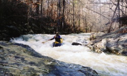
Falling essentially south off Sand Mountain, it is the only significant stream that comes close to flowing off the east 'back' side of the mountain. When we first ran it at 0" (too low), we thought maybe this was all just III+. It is definitely III+ to IV at decent levels, and goes to IV+ above 12". Scouting is easy throughout the run since the stream is seldom more than 50 yards from a rail line. What few logs were in Line were removed in November 2001.
The creek can be broken down into three parts. The upper mile+ is narrow and only carries a fraction of the take-out flow. This somewhat dictates minimum water because the take-out may be OK while the first mile is a hardship. It has several 3-6' drops and slides along with a couple rock jumble rapids. These are all II & III. The middle section has a few braids or splits. Here you go under the Railroad and past some big bluffs. The gradient is OK but no big rapids exist. There are some narrow spots and a few logs so caution must be exercised. Finally you pick up a few tributaries on the right and the steeper section begins. In fact, should you choose to trespass on CSX R/R property, you can save on shuttle time and just walk up and run the lower section. Walking takes about the same amount of time as running the first two miles (~30 min).
The third section begins with a triple drop totaling about 15'. The drops are separated by about 50' each and are quite straightforward. Next is the icebox, a partially collapsed old rockhouse / long undercut. This can be run one way or another depending on level. The stream goes over the normally dry rocks here at high water. A scout and short walk here my be probably required and at high flow you may not be able to paddle next to the cliff. Most of the steep part consists of 4'-10' slides and short vertical drops. The streambed is not too narrow but has steep rock sides so it channelizes pretty well. Two split drops towards the bottom have pinning potential but we have run them left without incident. One drop about halfway through harbors a sticky river wide hole above 8".
A gage on river right at the take-out bridge has been painted. 4" is painfully low, a few more inches is better, and 6"-8" is real fun. At 14", things get a bit serious with sticky holes appearing at the bottom of some slides. You must get to Line within one day after a heavy rain or immediately after a rain of 1.5" or so. It is not on the flow page because all the gages near it respond way too slow because their watersheds are much bigger and longer than Line's. In addition, the area around the gage is eroding a fair bit in early 2003, so 8" today may be a bit higher than 8" was in 2002.
I did Line yesterday (1/21/02) with a few friends. It was running 4" and only dropped 1" while we were on it. The upper slides were very scrapy. Things got better just above the Ice Box. Running the Ice Box was cool. The drops below were nicer than I expected. There were two logs in the upper part which we had to limbo under. I think at water levels around a foot you would not be able to fit under the first one and there was not much in the way of eddies above it at low water. There was also two logs together in the same spot which we had to walk around. This was somewhere at the half way point. - Brian McAnally (Things have not changed much as of 3/2004)