
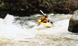
There is a short warmup after the Hwy 78 bridge, then the class II and III begins. You pass under a railroad bridge, and the drops get gradually bigger. There are a couple easily avoided undercuts. The rapids are all drop/pool. Two of the rapids towards the end are fairly large and might be IV or IV-. It's hard to characterize the boundary between III and IV on micro creeks. Do yourself a favor and don't go downstream of the first Winnataska Dr. bridge. Below there lies only Gum trees and flatwater as far as we could tell.
Kelly has been retrofitted with an online gauge courtesy of Streambeam, which can be accessed via the link below. This gauge updates several times per hour and is located at the takeout, giving an excellent idea of current flow conditions. Current correlations indicate 0.6' on the Streambeam gauge is a minimum, and upwards of 0.8' is decent flow. Additional visuals of the put-in gauge are welcome and can be submitted via the Streambeam web site to solidify the correlation between the physical gauge at the put-in and the SB gauge at the takeout.
Streambeam Kelly Creek Gauge
If the Streambeam gauge is down due to maintenance or server issues, Kelly Creek does host a USGS gage many miles and tributaries downstream. It seems that about 1500 cfs on the gage is a good low/med level. We ran it with about a 2' air gap under the put-in bridge river left piling horizontal cross member.
If you follow Winnataska Dr. to the next bridge downstream, you encounter Camp Winnataska. Next to the camp is a big 30-35 foot two part slide falls. To run it, you would have to do a 4 mile bridge to bridge (Winnataska Dr. to War Eagle or CR27) run because the folks at the camp are not going to let you take out on their land. I think this stretch will be quite flat except for the falls. There is something called Dukes Mill at War Eagle Rd, so perhaps there is another feature there to be investigated. We felt that 1500-2500 cfs would be a good level to run the falls.