
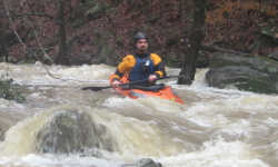


Keller has a small watershed so you need recent significant rain to make it happen. If you look at the pictures, this was a good level bordering on the high side. Keller has pretty good gradient but almost no abrupt drops. The rapids are fairly continuous, which makes dealing with the numerous logs a bit stressful. Once the action gets started in earnest not far below the put-in, it does not let up much for a good while. No rapids are really more than III+, but the length of a few at higher water with logs may bump it to IV here and there. It also has two major clearcuts along the banks which are not helping water quality or strainer density. That being said, it would be worth doing again if not for the takeout situation. Like a lot of creeks near Brindley Mtn (Cotaco for instance), Keller hits the flatlands long before it finds a bridge. This makes for long and painful flatwater paddles around and over logjams, trees, and fences. So Keller is a run to do if you are nearby, it has rained a ton, and suffering is called for.