
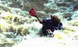
The take out is about 3 river miles down stream on Holt Peterson Road (county road 88). From Hwy 216, turn on to county road 88 and follow to the T intersection - turn left on Holt Peterson Road and follow to the bridge over Hurricane Creek. A guage has been painted on the bridge piling and can be viewed from the downstream side. No parking signs have been posted on both shoulders of the road - some parking may be available on the the left side about 100 feet up from the bridge (private property). There are no known hazards on this stretch of the creek and it can be floated by open boats from 1 foot up. Kayakers perfer 2 feet or more. Most holes wash out between 4-8 feet. The "m bend" offers several fun holes and pretty good surfing.
Unfortunately, we lost access to our put-in on an upper section of Hurricane Creek. I heard this past weekend (4/14/01) that we may lose access to our take out as well. I am working with the Strokers Paddle Club and local land owners to re-establish access to the Creek. In the meantime, don't use the upper section - these folks are shoot you and ask questions later kinda people!
Rand Mccredy