|
|
|
|
||||
|
Run: |
Hubbard Creek |
|
|
|
||
|
Section: |
|
|
|
|
||
|
|
|
|
|
|
||
|
Class: |
IV (IV+) |
|
Put-In: |
Hike in from FR633 |
|
|
|
Gradient: |
20(1st 0.5 mile), 160,
120, 140 |
|
Take-Out: |
FR 637C |
|
|
|
Length: |
3.55 + Barbaree/Cheaha |
|
Precip. Gages: |
|
|
|
|
Shuttle: |
FR637 / Cheaha
/ AL281 / FR633 |
|
Delorme Gazeteer: |
P. 32 |
|
|
|
Water Q: |
|
|
Primary Gage: |
None (maybe AL 281 or takeout
visual) |
|
|
|
Links: |
Required Level: |
Visual |
|
|
||
|
|
Indicator Gage: |
None, very recent rain |
|
|
||
|
|
TRIP REPORT |
Required Level: |
|
|
|
|
|
|
|
|
|
|
|
|
|
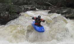
I try to use the words classic or gem
sparingly. But Hubbard is a really good paddle. If you savor the tiny steeps,
this is a succulent dish. A few of us may have been fortunate enough to make
the first run in March 2011 due to heavy lifting by Daniel Crow and Alf Van Hoose in 2010. They made several hikes checking it out
and removing all the dead trees. It took Daniel at least three trips. The
lack of trees made the run survivable at high water because it is severely
micro, pretty steep, and has limited visibility to say the least. One badly
placed tree and it would have been game over. As it is, this will be a seldom
run hoot until it fills up with trees again in a few years. Hubbard needs recent heavy rain,
and we had plenty that day. We arrived to find the take-out flooded and the
put-in in a similar state. The best place to put on is off FR 633. Turn north
off AL 281 and drive about ¾ of a mile to a turnoff on the right just short
of the private property. You can drag or carry your boats 250 yards east on a
4WD lane. Be aware google maps road names may not
reflect reality. The creek starts out completely
flat and may be up in the trees a bit if you have a lot of water. The first
rapid is the biggest rapid, a waterfall that should be runnable on the right at
sane levels. There is an 8ft high rock seive drop
almost immediately after the falls, so there is very little recovery time.
The next 1/3 mile or so is class II+ / III with very limited visibility. You
may be ducking under a lot of branches and craning your neck around corners.
The second major rapid is a two or three drop sequence (depending on water
level) where an 8’ sloping ledge just to the right of a rock in midstream
leads into a 5’ vertical ledge. The next part reminded me of the
upper upper Conasauga in
Georgia, only smaller. It was about 2/3 mile long with more or less
continuous class III+ / IV rapids, some of which are formed by long twisting
narrow bedrock. This part of the run is fantastic and drops at a rate of over
200 feet / mile. Somewhere along in here is an undercut / sieve on the left
that must be passed with caution. Then things ease off with ~1/2 mile of
class II+ / III+ rapids. Eventually you’ll encounter a potentially sticky
vertical 8 to 10 foot waterfall. Scout on creek right. Things then appear to
be over but two more biggies remain separated by about 100 feet. The first
looks really bad without water but goes. There are several smaller undercuts
around a broken ledge dropping about 4’ on the brink of a 10’ sloping
waterfall. The proper line will yield a large righty boof.
The second was much easier as long as the water is high. Approach left, slide
down a rock and then boof left off an 8’ high drop.
The last 1/2 mile is mostly class II / II+ rapids and then you hit Barbaree. The take-out is the same as Barbaree and lower Cheaha Creek
– the FR 637 low water bridge across Cheaha Creek.
You can get a rough idea of the water level at the low water bridge at the
takeout. See the last two pictures in the first linked set. This is a good
level if you can catch it. There is also a gauge painted on north side of
tunnel under AL 281. Read from creek left after 30 foot hike down the road
bank. Zero might give a minimal level, but it still has to be dialed in and a
beaver dam may be messing it up. |
|
|||||
|
|
||||||
|
|
||||||