
We put-in where the road comes close to the creek on Narrows Lane. You could put-in higher up but there is little gradient. The run length listed is from the confluence with Sand Valley Creek, although it may be hard to actually put-in right there.
There may be another section with low (20'+?) gradient above the confluence with the Locust south of Trafford...
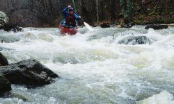
Renee Clark has a few words of caution:
Has anyone had trouble with the landowner on river left at the dam? We were there Saturday (1/26/02) and right after I took out on river right, a woman came running to the bank on river left yelling at the two paddlers in their boats. They were boat scouting the dam, but did not plan to run it. At first I thought she was trying to warn them not to run the dam, but then she got louder yelling about private property and get out immediately, pointing (actually waving madly) across the river. She then yelled that she was calling the cops and left when the boaters got out. We walked up the dead-end road to hwy 79, where we were parked. We saw her drive by, turn around and drive back by and then go back home. Anyway, it was unnerving. We had not planned on getting out on river left, but had observed when we parked that there was a church parking lot that we considered, which would have been on river left. That would have put us taking out on her property or having to walk down hwy 79 from river right to get to the car. Anyway, if you paddle there, watch out for her. She's got some real anger inside.
Editors note: I believe the case to be in Alabama, as it is in most states, that if you can legally access a run at the put-in and take-out, you can legally make the run. You can portage or scout up to the high water mark. No irate property owner wants to hear this, but I find it comforting in times of seemingly impending legal action.