
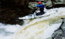
10' Vinemont Falls is about 1/3 mile below the CR 1386 bridge. It is not too difficult, though a curler from the left can cause problems. A back ender may greet your landing. The pool at the bottom is large. Several more II's and II+'s are found between the falls and the CR 1375 bridge. Above or around 1', the hole at the falls must be treated with respect.
Below CR 1375, the gradient picks up with a couple honest III's and one possible III+. The 'Enema Within' is probably the trickiest. At some levels it requires a ferry above a drop on river left with a hidden potential pinning rock. The action is fun all the way to the railway. Finally, Carpal Tunnel rapid is just above the tunnel under the railroad tracks. It is a pretty straight shot but could be a happening thing at high water. Watch for a rock towards the left side at the bottom. The paddle from there is flat and sometimes contains a few log jams, but takes only about 30 minutes.
This run features an online Streambeam gauge, accessible here, which is installed on the same structure (CR 1386 takeout bridge) as the old visual gauge and is calibated to read at the same scale. This gauge makes judging the level a snap before even leaving the house. On the gauge, 0' was a bit of a guess and would be low indeed. 6" is on the low side of medium but still fun. I've heard of one run at 1' 2", and that was good. Mark Coyle thought +/- 6" from this level is the sweet zone. Keep the feedback coming. The put-in road is actually on the same road as the put-in for Mill Creek, CR 1386 (Alvin Something? Rd) becomes Holmes-Drake Road as you drive north. The connection is not shown in the Atlas and Gazeteer.
JD reports on 3/6/04: Lotsa wood between CR 1386 & 1375, some riverwide. One is at the end of the pool at the bottom of the falls. Some can sneak up, but most of these are negotiable. Only one log below 1375, easily seen from upstream, but should be walked.
BTW, 1.1' is a prime level, I had perma-grin below CR 1386.
The hole below the falls is an issue at this level... a rope should be set.