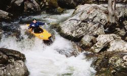
Dry/Sauty is somewhere between Johnnies and Jones in difficulty.
The small creek has some big drops formed by enormous boulders. It starts with some class IV with undercuts (see
pictures) right at the top, flattens out to III and IV for quite a ways, then the bottom drops out. Several steep
class V rapids with undercuts, sieves, falls, holes, etc. can be found. The steep part goes on for a fair while.
Towards the bottom you paddle through a clearcut with predictable log problems. Take out is at the boat ramp slightly
upstream on Lake Guntersville. The Shuttle is long for Sand Mountain, about 19 miles one way. About 85% of the
logs were chopped out of the upper 2/3 this run in the Fall of 1999, but to my amazement it has many logs back
in it in March 2001. The top part was again cleared in the fall of 2002. Running this with too much water might
be more excitement than you want. It does not take that much.
* A gage has been painted. 0' is about 3" above the upper, smaller shelf on the put-in bridge downstream concrete
support. This would be a good low level. We ran it once at about the shelf level and it was doable but painfully
low. This gage may be gone due a new bridge being put in, BTW.
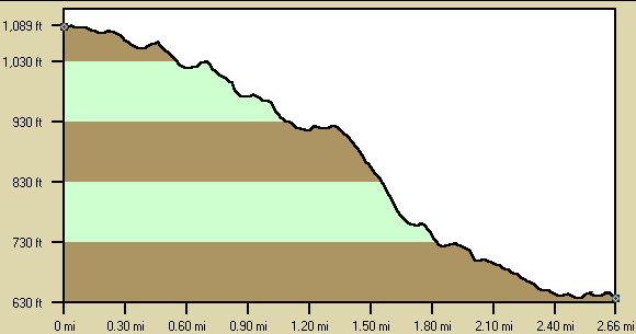
Below is a profile of the creek gradient. These data are not as accurate as the gradient field
above but do give a graphical feel for how the gradient is distributed. |