|
|
|
|
||||
|
Run: |
Dry (Coon) Creek |
|
|
|
||
|
Section: |
|
|
|
|
||
|
|
|
|
|
|
||
|
Class: |
IV-V+ |
|
Put-In: |
Gravel road in former Craze Bend
strip mine |
|
|
|
Gradient: |
200, 200, 260, 45 |
|
Take-Out: |
Boat ramp at end of CR491 |
|
|
|
Length: |
4 miles |
|
Precip. Gages: |
|
|
|
|
Shuttle: |
CR491 / Hwy117 / CR14 / CR81 /
Gravel** |
|
Delorme Gazeteer: |
P. 21 D6 |
|
|
|
Water Q: |
|
|
Primary Gage: |
None |
|
|
|
Links: |
Required Level: |
Visual |
|
|
||
|
|
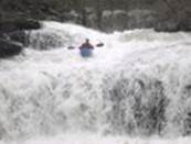
PICTURES |
Indicator Gage: |
Town Creek |
|
|
|
|
|
TRIP REPORT |
Required Level: |
~2000 cfs? |
|
|
|
|
Notes: |
|
|
|
|
|
|
|
Dry/Coon has a long history for a run
that just got done in 2011. For a creek with so much gradient and action, I
assume its obscurity is based on the fact that access did not look good for
many years. It was not obvious for a long time that roads even were near the
put in. But now with the advent of aerial photos and google
maps, you can tell that roads do exist in the old Craze Bend strip mines. I
have heard the mines were some of the largest in Alabama or maybe even
anywhere when they operated several decades ago. Anyway, Sloan Bryan told me about
Dry/Coon about 10 years ago. He had walked at least part of it. I eventually
walked in there and saw the stuff at the top. Later four of us cut out the
entire run in 2006. It was a brutal chopout as it
was full of trees. Events never conspired for us to get the first run. It’s a
bit out of the way and we saw it at low but maybe do-able water once and way
too low a few other times. Brian McAnnally and I
ran the first couple hundred yards in April of 2010, but decided to walk out
due to higher water than we wanted. Then in March 2011, Matt Wallace and
Chris McCoy ran the whole thing. Dry starts as two culverts under
the road. You can probably roughly judge the level by the culverts and just
downstream. If it looks pretty padded here it is high to me, but I’m not sure
of what it would be like down below. It is real tight at the top. Pretty soon
you get to the biggest single drop on the upper section. Matt and Chris
called it the Creecher. It is a complex class V
slide sequence into a clean vertical finish. After that things mellow for a
while with good drops. When you see the earth dropping away, you may be upon
one of the two sieves that Matt and Chris found at the top of the really
steep part. From my dry weather hikes I knew the next section would be
serious. It drops about 200 feet in ½ mile. Matt and Chris only had to walk
two logs and two sieves and pronounced it “oh so good”. This part is V+ for sure - steeper and harder than the
hair of the dog section on Jones. Closest thing Matt has run to the bottom 9.
After you pass another dirt road with culverts, Dry settles back to
manageable slides and you hit the flats into the lake. Access is not a problem if you can
read maps. Turn south off CR81 at House # 3450, which is the first road east
of the CR14/81 intersection. The dirt road will eventually come to a y
junction. Turn left here and the put-in bridge is just down the road a bit.
The shuttle is fairly long for Alabama since you have to go all the way to
the boat ramp on the lake. But at least the flatwater
paddle is shorter than Coon itself. You’ll need fairly
recent and significant rain to catch this run. I’ve been skunked plenty of
times. But Dry can also be too high. It may hold a tiny bit longer then some
micro runs because it is partially fed by ponds in the old strip mine area.
If things go badly, you can hike out river left and find a road that will
lead you back to the put in. Unfortunately the bridge at the end of the steep
stuff is all on private, gated land. |
|
|||||
|
|
||||||
|
|
||||||

View
Dry
Coon in a larger map