
-Brian McAnnally
|
|
|||||
| Run: | Devils Den Creek | |||||
| Section: | ||||||
| Class: | IV | Put-In: | Springville Rd | |||
| Gradient: | 224' in ¾ mile avg 298'/mile | Take-Out: | Cedar Brook Lane | |||
| Length: | 0.75 mile | Precip. Gages: | Wundergnd1 Wundergnd2 | |||
| Shuttle: | Springville Rd/ Remlap Dr (CR 19)/ Hwy 75/ Cedar Brook Lane | Delorme Gazeteer: | P. 31 A8 | |||
| Water Q: | Primary Gage: | None | ||||
| Links: | TOPO MAP | Required Level: | Visual | |||
| PICTURES | Indicator Gage: | ? | ||||
| TRIP REPORT | Required Level: | |||||
| Notes: | ||||||
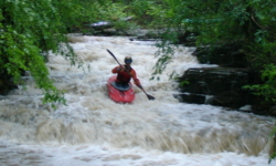
| This little gem was found by Tim Hudson, who scouted it and cut
the trees out. Devil's Den as the locals call it is not much more than a ditch at the put in and does not get much
bigger (when it has dashed lines on the topo maps, you know it is small -ed.). This is a short,
steep rocky run with few eddies. It is less than a mile but drops an average of 298'/mile, so if you are out in
the Pinson / Springville area after a HEAVY rain, check it out because it is a hoot. Look for water to be over
a large flat rock on river right just downstream of the put-in. Go left at the first island or if you go right
watch out for barbed wire. There is only one distinct rapid on this run and it is a 8' drop into a shallow pool.
Boof the drop on river right 5' or so from the right bank. You will know this drop is coming up when the river
constricts with only one runnable slot. Run the left slot being careful not to get stuck under the undercut and
then be prepared to drive right for the big boof. Be prepared to stop when the railroad trestle comes into view,
as of early 2008 there was a large log jam under it. Take out on river right and hike down the old railroad bed
until you come to your car. -Brian McAnnally |
||||||