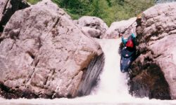
Put in at the downstream bridge at the intersection of 117 and 71 on Flat Rock Creek. Flat Rock would be a fun IV (V) run if only you could take out at where Coon begins. The run starts out easy, with a few class IIIs and a fair portion of flatwater. The action picks up after awhile and is really a lot of fun for the class IV appreciative crowd. Then there is at least one solid class V and a couple IV and IV+s before the confluence with Coon. One drop features a hard to avoid undercut wall on river right. Another just above Coon treated the author and his C-1 to a most enjoyable pin. The last rapid above Coon has a cool 10-12' slot drop as its climax.
Then Coon begins when a tributary joins after five miles of Flat Rock. The next mile drops 260'. There is no shortage of class Vs here. If the water is up, you will now know it without a doubt. Some rapids are not short, and the portages are not easy. This is the part that bogs people down since they are already tired. If you make it past this stuff, you get to enjoy the 4+ mile lake paddle to the boat ramp.
Coon used to be infinite chicken water quality due to strip mining. In fact the first party to run it is reported to have thrown their equipment away after their run. But the situation seems much improved since the demise of the steam shovel on the Alabama landscape.
*This will run with a bit less water than Jones. There is a small dam just upstream of the put-in bridge. If the water is going over that real well, the run will be too high. An inch or two is getting high. Just a thin film of water over the dam would be about right. Jones should be around 11" or so.
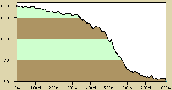
Below is a profile of the creek gradient. These data are not as accurate as the gradient field above but do give a graphical feel for how the gradient is distributed.