When you are running something that is a dotted line in the Gazeteer,
you know that timing is important. One must arrive on scene during or just after a heavy rain to have any hope
of finding water. We proved this yet again in March 2010 at Martin Hollow. Martin Hollow is a small ditch that
goes over a few nice drops on its way to the flatlands of the West Fork of Cotaco Creek and ultimately the Tennessee
River. The put in is just upstream of Childers Road. There is a bedrock drop upstream within sight of the bridge.
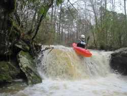
Just downstream of the bridge there is a clean 5' drop (clean if you don't get stuffed into the undercut on river
left), followed by an almost clean 8' drop. On the second drop, you want to get left or maybe right to avoid the
worst of the rock landing, which is actually a sloped rock with a protrusion on it. Downstream is more or less
continuous super tight IV until the confluence with WF Cotaco, with about three trees to deal with. As Tim put
it, "this would be full-on with 6 more inches of water".
On the WF Cotaco there are a couple rapids, a bit more water, and some nice scenery. The takeout is the key since
otherwise you are looking at about a four mile flatwater paddle out. Hike out at Frost Creek back up to Childers
road. Frost drops about 40 feet over 0.4 miles, so its an easy uphill. On WF Cotaco, look for a spring on river
left issuing forth from a cliff just upstream of Frost Creek. Hike river right up Frost, then ferry over to river
left in a rapid. You will undoubtedly notice the bonus feature on Frost just above the boulder rapid. Hike up past
the bonus feature (Tyler called it Brownbag Falls), then follow the trail to the road, which crosses over to river
right above the falls. The falls are runnable. More water is better to pad out the rocky steps.
You could easily walk the shuttle if you only had one vehicle. |
|