|
|
|
|
||||
|
Run: |
East Fork of the West Fork of
Little River |
|
|
|
||
|
Section: |
|
|
|
|
||
|
|
|
|
|
|
||
|
Class: |
II-III (IV/P) |
|
Put-In: |
Griff Johnson Rd (Georgia) |
|
|
|
Gradient: |
15, 35, 50, 15(0.4) |
|
Take-Out: |
Dekalb CR 517 |
|
|
|
Length: |
3.4 + 5 on Upper West Fork |
|
Precip. Gages: |
|
|
|
|
Shuttle: |
CR517 / CR631 (Cove in AL, Flarity Rd in GA) / Griff
Johnson |
|
Delorme Gazeteer: |
P. 21 F8 |
|
|
|
Water Q: |
|
|
Primary Gage: |
None |
|
|
|
Links: |
Required Level: |
Visual |
|
|
||
|
|
Indicator Gage: |
|
|
|||
|
|
TRIP REPORT |
Required Level: |
350 min, 450 good, 1200 cfs high |
|
|
|
|
Notes: |
|
|
|
|
|
|
|
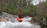
A river section is going to be a
bit obscure when it’s a fork of a fork. What happened to branches? Alf has
been snooping around the upper reaches of Lookout Mountain with mixed
results. But this is the prize run of the lot so far. This run is not a
classic by any means but if the water is fairly high and you want tight
without too much risk, it may be worth checking out. The first 3/4 of a mile
is almost flat and has a tree or two. You then arrive at a fun eddy hop or
sluice which is no problem at any level. It then mellows again before you hit
Long Branch, which comes in right in the middle of the biggest drops. Eddies
are small but available. At the bottom of the longest sequence a difficult to
reach boof is just around a tight turn. Immediately
after that the creek drops between and over some big boulders. The 6' drop on
river right was a no go for us due to a bad hole and log combo. With decent
water an easy line should open up on the left. The II and easy III is intermittent but fun down to the confluence with the
West Fork proper. Then you have one or two mellow drops with a lot of flatwater and three dams. Each dam could be very
dangerous and should at least be scouted. There are pleasantly few logs
considering the stream width and how bad some nearby runs are. There are a
few to go over and walk, and several to limbo under. The shuttle is short and
easy. The gradient is not easy to figure out since the USGS maps are in
meters. It takes less water to run this than you might imagine. We ran it at
low but acceptable water just after the west fork gauge peaked at 360 cfs. |
|
|||||
|
|
||||||
|
|
||||||

View EFWFLittle in a larger map